Spyglass
Napsal: 23. 12. 2017 07:06
Spyglass v3.0.0 [Pro]
Požadavky: Android: 5.0 a vyšší
Popis:


Vice info:
Stahuj zde: PRO features Unlocked
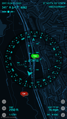
Packed with tools it serves as binoculars, heads-up display, hi-tech compass with offline maps, gyrocompass, GPS receiver, waypoint tracker, speedometer, altimeter, Sun, Moon and Polaris star finder, gyro horizon, rangefinder, sextant, inclinometer, angular calculator and camera. It saves a custom location, navigates precisely to it later, shows it on maps and using augmented reality displays detailed GPS info, measures distances, sizes, angles, and does a lot more.
INPORTANT NOTE ON ANDROID RELEASE:One of the best cross-country GPS navigation tools is now available on Android. Most features are implemented, however, some features available on other platforms are to be done. The multi-target tracking, star catalogue and coordinate converter will come later as a free update. Also, instead of having multiple apps, on Android it is a single free app with a paid unlock of premium features.
COMPASS & GYROCOMPASS:Accuracy improvement techniques, special compass modes and calibration methods available in Spyglass only make it a real instrument – the most advanced and accurate digital compass.
FINDER, TRACKER & AR NAVIGATION:Spyglass operates in 3D and uses augmented reality to show object positions, info and directions to them overlaid over camera or maps.Save current position, add a point from maps, manually enter location coordinates.Find the saved place later simply by following directional arrows.Spyglass tracks your target and shows its info – distance, direction, azimuth, elevation and estimated time of arrival.
GPS, SPEEDOMETER & ALTIMETER:Find and track your location and get detailed GPS data – coordinates in dozens of formats, altitude, course, current, maximum and vertical speed, using imperial, metric, nautical and surveying units.
OFFLINE MAPS:See your and targets’ positions on maps using different map styles and alternative map providers – plan waypoints and measure distances. Offline maps optimized for retina displays are available for download.
TRACK POLARIS, SUN AND MOON & NAVIGATE BY STARS:Track positions of Polaris, Sun and Moon with arc second precision – use them as a reference to calibrate compass for maximum accuracy.
OPTICAL RANGEFINDER:Measure distances to objects in real time with a rangefinder reticle similar to sniper sights.
SEXTANT, ANGULAR CALCULATOR AND INCLINOMETER
Find out heights of objects and distances to them – measure visually and calculate dimensions and distances.
CAMERA:Take pictures overlaid with all available GPS, positional and directional data.
Požadavky: Android: 5.0 a vyšší
Popis:
Screen:Spyglass je nezbytná offline GPS aplikace pro venkovní a off-road navigaci.
Vice info:
Kód: Vybrat vše
https://play.google.com/store/apps/details?id=com.happymagenta.spyglassKód: Vybrat vše
https://www.ulozto.net/!nr4KWCeMwEWz/spyglass-pro-3-0-0-apk
https://webshare.cz/file/3t92kQ205t/spyglass-pro-3-0-0-apkINPORTANT NOTE ON ANDROID RELEASE:One of the best cross-country GPS navigation tools is now available on Android. Most features are implemented, however, some features available on other platforms are to be done. The multi-target tracking, star catalogue and coordinate converter will come later as a free update. Also, instead of having multiple apps, on Android it is a single free app with a paid unlock of premium features.
COMPASS & GYROCOMPASS:Accuracy improvement techniques, special compass modes and calibration methods available in Spyglass only make it a real instrument – the most advanced and accurate digital compass.
FINDER, TRACKER & AR NAVIGATION:Spyglass operates in 3D and uses augmented reality to show object positions, info and directions to them overlaid over camera or maps.Save current position, add a point from maps, manually enter location coordinates.Find the saved place later simply by following directional arrows.Spyglass tracks your target and shows its info – distance, direction, azimuth, elevation and estimated time of arrival.
GPS, SPEEDOMETER & ALTIMETER:Find and track your location and get detailed GPS data – coordinates in dozens of formats, altitude, course, current, maximum and vertical speed, using imperial, metric, nautical and surveying units.
OFFLINE MAPS:See your and targets’ positions on maps using different map styles and alternative map providers – plan waypoints and measure distances. Offline maps optimized for retina displays are available for download.
TRACK POLARIS, SUN AND MOON & NAVIGATE BY STARS:Track positions of Polaris, Sun and Moon with arc second precision – use them as a reference to calibrate compass for maximum accuracy.
OPTICAL RANGEFINDER:Measure distances to objects in real time with a rangefinder reticle similar to sniper sights.
SEXTANT, ANGULAR CALCULATOR AND INCLINOMETER
Find out heights of objects and distances to them – measure visually and calculate dimensions and distances.
CAMERA:Take pictures overlaid with all available GPS, positional and directional data.