Coordinate Master
Napsal: 29. 10. 2018 18:35
Coordinate Master v4.3 [Paid]
60,-Kč
Požadavky: Android: 4.0 a vyšší
Popis: This powerful geodesy app allows you to convert coordinates between many of the world's coordinate systems, compute geoid offsets, and estimate the current or historic magnetic field for any location. It also includes surveying tools to compute the point scale factor and grid convergence.
Screen:


Vice info:
Stahuj zde:
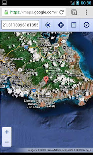
The app either takes manual coordinate input or uses your current GPS location. The computed location can be displayed in Google Maps via your web browser with a single button press. It also supports MGRS grid references.
You can export any lat/lon, UTM or transverse Mercator coordinate systems to a HandyGPS datum (.hgd) file for use as a custom datum in HandyGPS.
The magnetic field calculator page computes the Earth's current or historical magnetic field at a given location. The magnetic declination computed is useful for compass navigation since it represents the difference between true north and magnetic north. Field inclination and total intensity are also computed. This tool uses the International Geomagnetic Reference Field model (IGRF-12).
60,-Kč
Požadavky: Android: 4.0 a vyšší
Popis: This powerful geodesy app allows you to convert coordinates between many of the world's coordinate systems, compute geoid offsets, and estimate the current or historic magnetic field for any location. It also includes surveying tools to compute the point scale factor and grid convergence.
Screen:
Vice info:
Kód: Vybrat vše
https://play.google.com/store/apps/details?id=binaryearth.coordsystool&hl=enKód: Vybrat vše
https://upload4earn.org/td9aw8i9ubw7
https://douploads.com/q4kow5v7hu1zYou can export any lat/lon, UTM or transverse Mercator coordinate systems to a HandyGPS datum (.hgd) file for use as a custom datum in HandyGPS.
The magnetic field calculator page computes the Earth's current or historical magnetic field at a given location. The magnetic declination computed is useful for compass navigation since it represents the difference between true north and magnetic north. Field inclination and total intensity are also computed. This tool uses the International Geomagnetic Reference Field model (IGRF-12).

